This week I had my second week of Geology 210, Field Studies. This week was very different from last week. Like almost entirely different. Last week was a very detailed study of one particular area; this week was a broader overview of numerous places. Last week was hiking all day; this week was mostly driving, with periodic stops. Being the lazy person that I am, I liked this week better.
(I make the same disclaimer I did last week: I am not a photographer, nor do I claim to be one.)
On Monday we met in the classroom to go over the geologic history of Utah and discuss some logistical things. Our professor was Dr. "Doc" Tom Morris. We were amused by his lexicon--"beefy burgers," "munchy bars," "groovy souvies" (souvenirs)--and his recurring expressions ("Screw your neighbor" and "If you can't see that [fault, rock contact, etc.], psychology is a great major"). We introduced ourselves to the class. There were three people in the class who were physical science education majors, and the rest were all geology majors. That means that in the entire class of about forty people, I was the only geology minor, the only person not in a major from the College of Physical and Mathematical Sciences, and the only person who didn't need to take the class. We got out in the afternoon, and it was only in the 70s, so I went running. I think it was the first time I've ever gone running during the day in the month of August.
Then Tuesday morning we were off again. We headed down on I-15. We got out at various stops and looked at the geology nearby.
While driving through Utah, I have often noticed hills with basalt capped on top. Now I finally know why they are there. If I understand it correctly, lava flows down to the bottoms of valleys and deposits as basalt. Basalt is more resistant than sedimentary rocks, so the surrounding rocks erode away, but the basalt remains. Since it is on the top, the rocks beneath it are not eroded. Therefore, the basalt was once at the bottom of a valley, but it is now on the top of a ridge. This is known as an inverted valley. We saw one near Toquerville.
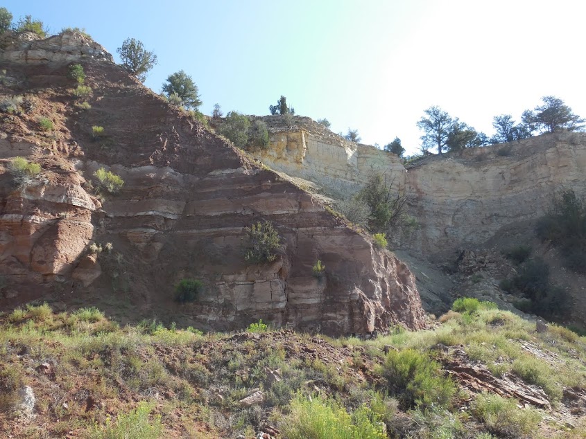
A little further south, we stopped at looked at the stratigraphy. Normally I wouldn't care to show it to you, but I was pleased with the image I made. (I'm not sure if I got the boundaries of the formations quite right.)
Rocks turn red when they are deposited in oxygen-rich environments. They turn red because of the iron. All of the rocks in the above picture are Triassic in age (around 247 million years ago). Utah was on the coast at that time, and these rocks deposited in a tidal flat environment.
Then we made it to Zion National Park. I went to Zion in 2002 and in 2010, so it wasn't entirely new to me. We set up our camp, then we went and got on the park's shuttle. I wonder how much we annoyed the tourists throughout the course of our trip, since there were around forty of us. On one of the shuttles, one of my classmates met some people from Russia whom he knew from his mission. ("That would never happen at the University of Utah," Doc said.)
We went to Weeping Rock, which is an alcove in the sandstone where water percolates through the sandstone, hits an impermeable layer, and then flows out until it can find someplace else to go--in this case, the alcove. One of the major formations of Zion is the Navajo Sandstone. Back in the Early Jurassic (about 185 million years ago), Utah was covered in a sea of giant sand dunes, much like the Sahara Desert today. These sand dunes were turned to rock when groundwater rose and froze the sand dunes in place, forming the Navajo Sandstone. All throughout the park, you can see bedding planes of the ancient sand dunes.
The cement of the Navajo Sandstone (what holds the sand grains together) is calcium carbonate. As water flows through the sandstone, it dissolves the cement. At Weeping Rock, it deposits the calcite again as a kind of limestone known as tufa. (Prior to this class, I thought all tufa came from springs and formed around plants, but apparently that's not always the case.)
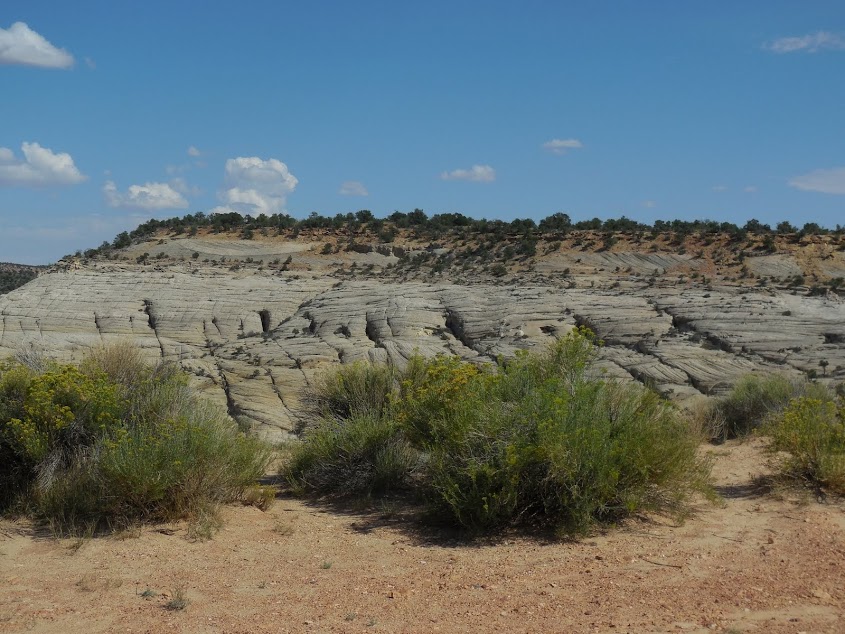
Another stop in Zion was the Checkerboard Mesa. I have seen it before, but I wasn't that impressed previously.
The Checkerboard Mesa gets its name from the vertical and horizontal lines. The vertical lines are fractures in the rock. The horizontal lines are the base of different levels of sand dunes. I don't think the Checkerboard is that amazing from a distance--but we got to go up close, and it was really cool.
We all climbed on the Checkerboard Mesa to hear Doc tell the story of Milutin Milankovitch, a story he told last year in a
BYU devotional. Since I'm a scaredy cat and don't have good balance, I didn't climb as high as the rest of my class (Doc told us not to if we didn't feel up to it; there were also three girls who didn't go up all the way). There were several people who took pictures of us as they drove by. I guess we do provide a perspective for how big the mesa is.
The next morning (Wednesday), we left Zion after taking some measurements of the dip direction of the bedding planes of the Navajo Sandstone. One thing that this class (both this week and last week) has taught me is just how common faults are. We found numerous faults throughout the trip. This one is especially obvious, as shale is place directly next to limestone. I think that in this case, the limestone (on the right) was shoved upwards.
There was also a smaller fault at that same location.
Later that day we stopped at Coral Pink Sand Dunes. This is a relatively small dune field. We sat in the sand as we received instruction. Afterward, many people played in the sand, but I didn't because I got my fill at Death Valley, I didn't want to be sandy all day, and there were lots of plants in these dunes.
There was a fence placed to prevent cars from driving on the dunes, but apparently the dunes have migrated and partially eaten the fence.
Near Orderville, we got out and took a quiz. It was one that was very difficult (Doc told us we were all going to fail), so I was fine with my score. Then we headed toward Bryce Canyon. Outside of the park, we found this very cool fault, where basalt-covered rocks are lifted up against the red eroded rocks.
Then we headed closer to the park and stayed at Ruby's Inn Campground, where my family had stayed back in 2002. We just got to relax that afternoon. I wanted to go swimming, like others did, but I thought there was going to be a thunderstorm. There are some people whom I want to be in a swimming pool during a thunderstorm, but I'm not one of them. But the thunderstorm never came our way, so I could have gone. I took my swimming clothes for nothing. That night we went into the park to see Bryce, but we missed the sunset, so the pictures weren't the greatest.
Bryce is one of the most--if not
the most--stunningly beautiful places I've ever seen. Can you imagine being one of the first explorers or pioneers to come across the place, having never heard of it or seen pictures? That would be so amazing! That night I bought a "groovy souvie" of a t-shirt, but I later discovered it was a ladies' shirt, so it doesn't fit me. *sigh*
The next morning (Thursday), we returned to Bryce to learn about it.
During the Eocene Epoch (about 55 to 35 million years ago), there were large intermountain lakes in Utah that deposited the Claron Formation, which makes up Bryce Canyon. So the rocks of Bryce Canyon aren't really that old. Bryce Canyon is pretty simple; there are three kinds of erosion that create the formations: headward erosion, downcutting, and slope retreat. (I don't understand those processes that well, so I won't explain them.)
We hiked down into the canyon. These icicle-like structures are from water both eroding and depositing mud on the cliffs.

These trees were pretty cool.
On the trail we even saw some bridges. We were stopped on the trail and Doc asked us what the difference was between arches and bridges. We didn't know, but a random foreign tourist did--arches are formed from seeping or percolating water, while bridges are formed from running water. We saw a few bridges on our walk.


After we left Bryce, we drove through more locations in southern Utah. At one location, we got out and talked about the Navajo Sandstone. The sand grains in it are mostly made of quartz, which comes from igneous rocks. The sand grains of the Navajo formed in the Grenville formations of the Appalachians, a formation that formed 1 billion years ago. Eventually the igneous rock eroded until most of it was quartz, quartz being tougher than most other minerals. The grains were carried down by rivers into Utah, where they made up sand seas that covered four states. Then they turned into rock. Doc pointed out that there was no way they would be able to go through that many processes in a mere 6000 years. Doc said that the more he learns about geological processes, the more he sees the structure of the system and the more he believes in a creator--which is
how I feel. Doc said there must be a purpose to our lives--otherwise he would probably eat his students instead of smiling at them.
I noticed another structure that looked a lot like the Checkerboard Mesa, so I asked Doc if it was the same thing going on. He said it was.
That afternoon we stopped at Twin Rocks near Capitol Reef. We climbed by the rocks and had to memorize the nearby Triassic formations. My camera battery was dead at this point, so my pictures from hereon out are all bad, since I had to use my phone or else had to use my camera really fast before it remembered the battery was dead.
Capitol Reef is the one of Utah's five national parks that I'd never been to. Doc likes it the most because it has seventeen geological formations, while Zion only has three. That night we set up camp, then we drove to a nearby town to get some "beefy burgers." It was fun riding back in a van full of twelve college students all rocking out to Queen. And people think that BYU students don't have fun!
Friday was our last day out in the field. In the morning, we went and looked at some more rocks. My favorite part was the reptilian trackway. These are part of the Triassic rocks. The currents in the rock indicate that the reptile was struggling against the current.
Then we went and saw the Goosenecks, which are meandering streams in the rock. These meandering streams are enigmas, because usually meandering streams form on flat surfaces. There are a few theories as to why these meanders are here; Doc thinks it's because the river follows fractures.
Then we went and saw various other places in Capitol Reef. I got another groovy souvie of a deck of Capitol Reef cards. We saw various other things in Capitol Reef, such as an outcrop of the Entrada Sandstone;
some dinosaur bones from the Morrison Formation of the Jurassic, when Utah was an alluvial plain;
and the "capitol" for which Capitol Reef is named. At least I think it's the capitol. The "reef" part of Capitol Reef comes from the sailors who named the area--the area was suddenly less navigable, just as a reef is problematic for sailors.
Our last place was closed due to a rockfall, so we went to another place nearby. Basalt boulders are all over Capitol Reef. We sat on some while we heard Doc lecture, but sitting on them was like sitting in an oven.
Then we loaded up and went home!
Then yesterday I spent about eleven hours retyping up my field notes, since we are graded on them. I'm not even finished yet. It was not my ideal way to spend the last Saturday before the semester starts.
But I will have three full credits finished at the very beginning of the semester!


No comments:
Post a Comment